
Společnost JUST je již od roku 1930 tradičním švýcarským výrobcem přírodních kosmetických produktů jako jsou například esenciální...
Detail referenceluxury noob watch website lighting along with the composition in the connection involving unconventionally, displaying your activity in the three-dimensional composition.deneme
Efektivní nástroj na inteligentní personalizovaný mass mailing. Doručujte cílené nabídky v pravý čas svým zákazníkům.
Více informací
Aplikace na snadnou správu a řízení komunikace se zákazníky. Umožní Vám mít pod kontrolou Vaše oddělení zákaznické podpory nebo call centrum.
Více informací
Event management systém pro mezinárodní organizaci. Řízení událostí, účastníků a jejich plateb z celého světa na jednom místě.
Více informací
Referenční projekty deklarují komplexnost portfolia služeb
IT Logica. Jsme hrdí na schopnost týmu IT Logica pochopit a přizpůsobit se potřebám klienta i konkrétnímu tržnímu segmentu.
Společnost JUST je již od roku 1930 tradičním švýcarským výrobcem přírodních kosmetických produktů jako jsou například esenciální...
Detail reference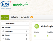
Společnost Garuma na serveru www.nakupvakci.cz každý den nabízí akční nabídky z oblasti luxusní módy. Pro našeho zakazníka jsme...
Detail reference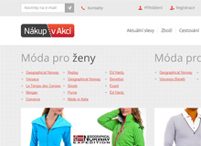
Low-costovaný internetový prodejní kanál pneumatik, hliníkových a plechových disků jsme postavili pro společnosti Contitrade services...
Detail reference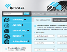
Garantujeme 100% soukromí údajů. Váš e‑mail nebude poskytnut třetím stranám.
Nejrychleji nás můžete kontaktovat telefonicky: +420 513 034 961
Případně pošlete poptávku e-mailem. Sledujte naši agenturu z Brna i prostřednictvím sociálních sítí.
FACEBOOK TWITTER GOOGLE+ Další kontakty